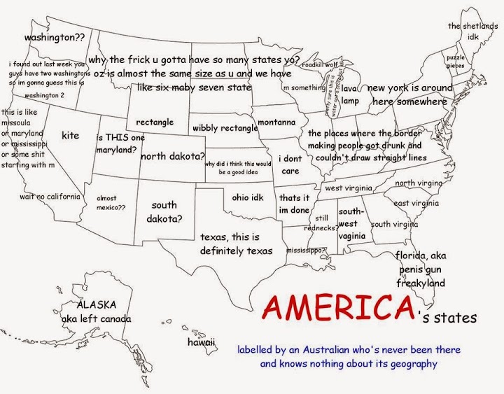
here, I thought this was lol
Better than I could do for Australia. And I’ve been there, I have no good excuse.
Hey, he got the Pacific states perfectly.
Wonder if Texas has been nailed due to Bush popularity or because of Texas Instruments. I know because of the latter.
Cool! I live in “why did I think this would be a good idea” and grew up in “ohio idk” (also known as Oklahoma). 
I can only identify a few of the states myself. Distinctive ones, mainly. If I learned the entire map in school, it was so long ago I don’t even remember knowing.
Grew up in “lava lamp”, previously lived in “m something” and “north virginia”, and currently a resident of “not even gonna try with these lil ones”.
I recently asserted that Wyoming is bordering Oregon and both states are on Pacific time. I was fairly embarrassed to discover that there’s a whole state in between them (and Wyoming is not, in fact, on Pacific time*) - although, to my extremely minor credit, I didn’t have a map anywhere in sight, labeled or unlabelled.
I used to be able to identify every state and name its capital, but 3rd grade was a long time ago.
[size=85]* Which gives my girlfriend even less of an excuse for calling me at horrible-o-clock in the morning** during her recent visit to Wyoming, which is how this came up in the first place.
** Though it was nice to hear from her.[/size]
I can totally identify every state, thanks to being far too obsessive about maps. And being somewhat obsessive about fivethirtyeight for the past few election years. New England is the trickiest bit, but I think I could figure it out from having ruthlessly colonised it many, many times in Europa Universalis.
Now I kind of want to see what happens when people try to do this with African nations. Or, on second thought, maybe I really really don’t.
Oh dear, I think not.
I can pretty much identify every state looking at a map except Missouri, Arkansas, and Kansas (I sometime have brainlock which is New Mexico and Arizona, though having driven from Lubbock to Santa Fe should help there). Not sure if it’s electoral maps or generally being surrounded by maps for the benefit of children. I grew up in Pittsburgh, just above the “b” in border-making people got drunk, and have been known to give people grief for claiming that it’s East Coast. But I couldn’t tell you much about relative geography if I weren’t looking at the map.
Hopefully my Australia map would not offend: It’s a dot in the lower right labeled “Sydney,” one below it labeled “Melbourne,” one above it labeled “Brisbane,” one a titch to the left labeled “Canberra (actually the capital!),” one on the upper left labeled “Perth” and then the rest says “OUTBACK” in giant letters with Alice Springs in the middle.
Perth is in the southwest, not the northwest. Otherwise pretty good! Better than I could do for US cities.
Actually I’m pretty sure I could do a better job with African nations than US states. My grasp of US geography is appalling. I can identify California, Florida, Illinois, Iowa, Alaska, and Hawaii (ETA: oh, and Texas, of course!), and then I start handwaving and labelling things “New England”, “Republicans”, “Democrats”, “tornados”, “only place where four states meet”, etc.
Long long ago, my brother and I had a competitive game of naming every country in the world. We got pretty good at this, using a folding map that you could write on with washable markers.
Then the USSR broke up. After all that effort. I was so mad.
I learned the location of all clickably large countries from a Flash game I can no longer find. But I see the Guardian has a better one.
Happy Saturday, folks.
At about the age of fifteen or so, a friend and I took on our French teacher to a capitals-naming challenge. We lost because she’d been going off a different list from us - we hadn’t memorised dependent territories and other only-kinda-nations. She had planned for it to be an object-lesson in how much vocab we could memorise if we really put our minds to it, but what we learned was the importance of getting adults to define their terms.
At pub trivias (here in Sydney) almost every week there are questions about American states, so I get a lot of reinforcement on the names. But I personally don’t get much reinforcement on the geography because personally I’m really bad with the world map and where things are in relation to other things.
-Wade
I’ve seen another map of America by a non native that had the left third of the map marked as “California”, the right half as “New York” and “Florida” and then the word “FARM” written on the middle third. Sad part is there are Americans who’d do about that well if asked.
I live(d) in North Dakota? and texas and rectangle.
Wow, that’s pretty awesome.
I was lucky enough to have wooden puzzle-maps of European and African nations as a kid. So I can scramble smaller countries (Rwanda/Burundi were glommed with Tanzania, and I mix up Lesotho/Swaziland too) and the islands. Plus I am clueless on the Soviet republics. I’ll mix up Azerbaijan and Armenia all day and I’ll never pin down Lithuania/Latvia/Estonia in order. That’s life.
I think one of the big things that drive what I know/remember are sporting events/leagues/conferences–thanks to the Football Pyramid I have a decent grasp of the English counties and cities that way & knowing, say, Nebraska/Oklahoma (no more now the Big 10 has 14 teams,) Oklahoma/Texas or Georgia/Florida helps me visualize the states without a map.
As for American geography, this is probably too much detail for most people, but I think the big ones that we all switch are Alabama/Mississippi and Vermont/New Hampshire (seriously, they’re just the same size and shape, rotated!) Mnemonics can help–for instance, Mississippi borders the Mississippi River, and from US History class, Missouri/Kansas was the John Brown affair and there was the Kansas/Nebraska act. You can probably chunk the 13 original colonies together too if you want.
(Side note: I remember swapping county/state quizzes with someone in England and I was pretty sure they were cheating since they got the big vacated states (Wyoming) right and few else. What people guess here confirms that.)
But I know one of the most useless memorization drills/quizzes in class was to memorize the capital cities.
For confusion’s sake, major cities that are not capital cities: Chicago, Dallas, Houston, San Antonio, San * in California, Oakland, Los Angeles, Seattle, Portland (that one Cheers episode ended with an argument over this,) Detroit, Las Vegas, Pittsburgh, Philadelphia, Phoenix, Cleveland, Cincinnati, Kansas City, St. Louis, Milwaukee, Charlotte, New York City, Memphis, Baltimore, Tampa Bay, New Orleans, and Miami. Oh, Iowa City isn’t big, but it isn’t a capital, which screams silly logic.
Stephen Fry’s America DVD is a neat account of his travels and probably a lot more fun than memorizing.
Also, sheppardsoftware.com has lots of quizzes including an absolutely brutal in many ways quiz about island countries in the Pacific. Go learn a new language instead, or something.
When I was younger I had a state naming game on PC called “Name that State”. I probably couldn’t get them all exactly right now; I’m better at British counties. I can always find Wyoming though!
1 Like
aschultz – actually Phoenix is the capital of Arizona. You could probably add in Orlando and Jacksonville, which both seem like bigger cities than Tallahassee. And the biggest city in Vermont (hint: we’re the New England state with no coastline) is Burlington, but the capital is Montpelier, which is the smallest state capital and the only one without a McDonald’s and probably a few other things. It’s cute and has some good bookstores, though.
Albuquerque is another one; it’s quite a bit bigger than Santa Fe. Also Minneapolis, though the capital’s in its twin city.
Oops. I thought Tucson was the capital. SOmetimes I can double reverse myself like that, or my own reasoning fails. Since Tucson is where University of Arizona is. Thanks for the note on Vermont. I’ll remember that.
And Joey, that makes tons of sense–though I can also see confusing Wyoming for Colorado, the other squarish state (unless I remember the 4 corners) the person in question totally waffled when I asked how they knew certain states.
Thanks for the link to the Guardian flash game. Though I now want a minicomp where you have to play the flash game, then write a game about a country you misidentified/couldn’t find. As an added bonus, this would make http://ifwiki.org/index.php/Games_by_Country lots more interesting.