The sand dunes are currently winning, 4 to 2 to 2, which means it’s time for…
Chapter Five - 59 Seconds, 852 Feet
Big Kill Devil Hill
You stand on the brow of the largest of the four Kill Devil Hills, sand dunes on the North Carolina coastline. A few miles due north is the tiny village of Kitty Hawk, and just below you down the slope is some kind of wooden railing.
It’s a cold, windy day, and the great expanse of the Atlantic (to the east, of course) is combed by the waves swept back.
A paper dart lies nose down in the sand, ruffling in the wind.
It’s currently 11:42 am, and the year is 1903. And based on where we are, I suspect it’s specifically December 17th.
The paper dart (what we’d now call a “paper plane”, but of course they didn’t have planes yet) unfolds into a copy of the Cincinnati Herald:
The December 12th, 1903, edition, which is laceratingly cruel about the second hopeless failure of Dr Langley’s so-called flying machine “Aerodrome”, which crashed into a canal yards from take-off despite all the money the Smithsonian and the U.S. Government could put in. Dr Langley, it seems, blames his $50000 launching ramp and is confident the machine is sound. The “Herald” begs to differ.
I’m not sure which directions we can go, but the description mentions north, east, and down, so let’s try…east!
Atlantic Beach
Down at sea level, the sand is wet and an effort to wade through. The slope rises to the west, where a path winds up to a wooden hut. The vast ocean is choppy and boatless. Regular gusts of wind blow up great waves.
A bottle, containing a rolled-up message, bobs away out on the waves, not far from the shore.
Ooh, bottle!
>get bottle
The bottle is too far out to reach.
The bottle washes a little closer to you, but it’s still some way off.
I said…
>get bottle
The bottle is too far out to reach.
The bottle eases closer yet, bobbing on the waves.
Come on now! I SAID…
>get bottle
You just manage to reach the bottle without falling in, and pull out the message:
“Couldn’t face putting troubles in their way - both such nice boys, trying so hard. Perfect weather conditions today and they still wouldn’t fly, because it was the Sabbath! Anyway, it’s too cold to hang around.”
A signature seems superfluous. You bury the Coke bottle, just in case, though it hardly seems much of an anachronism.
There we go! So Black stopped by…four days ago? December 17th, 1903 was a Thursday. And decided not to ruin their experiments. How nice of them!
This is another place where I’m not sure it would really change history all that much if they failed. All their previous attempts did, after all, and even if Black outright killed them, other people were working on powered flight at the time. I wonder what happens to the timeline if we sabotage them ourself?
>n
Little Hill
Looking north, there’s nothing but miles of sand-bank and bicycle tracks to Kitty Hawk. South, the ground falls to the valley, and east to the beach.
Oh, so we’re west of the beach now? Northwest?
>s
Dune Valley
A valley among the dunes. A bicycle track runs north for some way in the direction of Kitty Hawk, rising to the south. The hills are as lifeless as the moon; spars of old trees, broken by frequent storms, break surface here and there; pools of water have frozen in the sand; cold wind comes and goes in gusts.
Oh boy. I’m lost.
>s
By the Railing
On the shallower northern slopes of Big Kill Devil Hill, thirty yards or so to the west of a wooden hut.
A single wooden rail runs along the ground and slightly downhill to the north for some sixty feet or so.
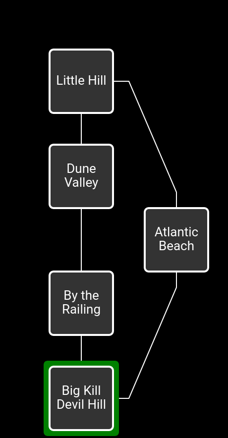
Okay, so now we’re north of our starting position.
>s
Big Kill Devil Hill
You stand on the brow of the largest of the four Kill Devil Hills, sand dunes on the North Carolina coastline. A few miles due north is the tiny village of Kitty Hawk, and just below you down the slope is some kind of wooden railing.
It’s a cold, windy day, and the great expanse of the Atlantic (to the east, of course) is combed by the waves swept back.
>e
Atlantic Beach
Down at sea level, the sand is wet and an effort to wade through. The slope rises to the west, where a path winds up to a wooden hut. The vast ocean is choppy and boatless. Regular gusts of wind blow up great waves.
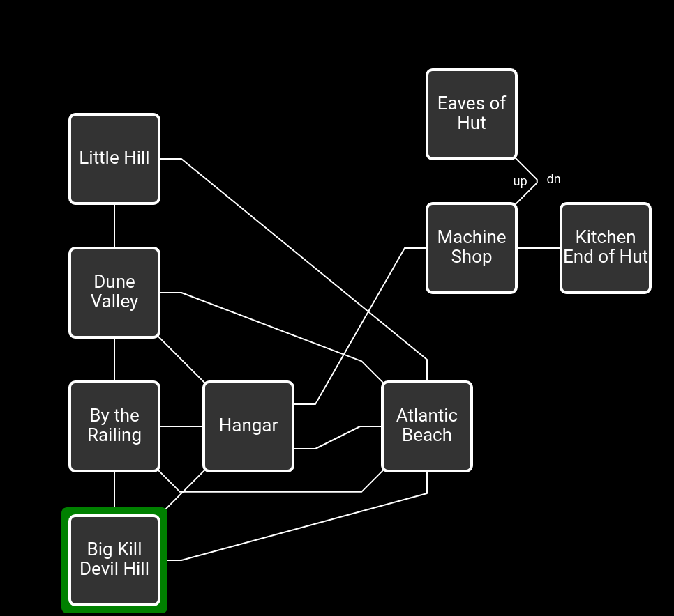
Right, okay. I think the map looks something like this.
So if we go west from here, we’ll end up…
>w
Just as you approach the hut, men heave an early biplane out of the hangar and towards the west. There seems to be quite some activity over there now, whereas it’s deserted here.
Hangar
A one-storey wooden hut, with a tacked-down tar pitched roof, about twelve yards by five, serves here as a hangar. The western wall has been opened up like a garage door and stands on three stilts. A bicycle track runs down the dune northwest, and footsteps in the sand trail away east to the beach, but the hangar really faces the rails to the west. A signal flag is flying.
A Richard’s anemometer lies among coffee mugs on a table on the “porch” of the hangar.
A lump of corn bread is all that remains of breakfast.
An anemometer is a device that tells us the wind speed, currently 7mph. From a Google Image search it seems Richard’s makes the kind with the little cups that spin around (rather than the ones that look like handheld fans). Looks very sciencey when you go around holding it up.
Grab everything, and keep exploring!
>w
By the Railing
On the shallower northern slopes of Big Kill Devil Hill, thirty yards or so to the west of a wooden hut.
Wilbur is tightening the wire-pulls to the wing warping.
Orville is adjusting the engine.
The “Flyer”, a flimsy but expertly-made biplane, is mounted on the rail.
A small crowd of spectators and witnesses from Kitty Hawk has gathered here and is looking on with some interest. They have no objection to your joining their number.
A single wooden rail runs along the ground and slightly downhill to the north for some sixty feet or so.
The brothers shake hands as Orville climbs into the “Flyer”, lying flat on his face on the bottom wing.
Ooh, this looks promising. But I’m going to undo to keep exploring first before anything serious happens.
>nw
Dune Valley
A valley among the dunes. A bicycle track runs north for some way in the direction of Kitty Hawk, rising to the south. The hills are as lifeless as the moon; spars of old trees, broken by frequent storms, break surface here and there; pools of water have frozen in the sand; cold wind comes and goes in gusts.
Up on the hill, the brothers are checking out the “Flyer”.
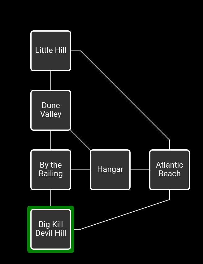
Okay, so the map is more like this.
Kinda looks like an airplane wing, doesn’t it? That’s a neat coincidence (or aesthetic decision).
>w
West Hill is not a very exciting place.
Up on the hill, one of the brothers gets into the “Flyer”.
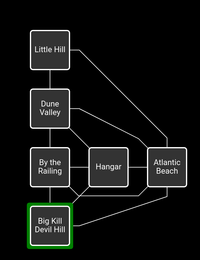
So I think this is our map.
>z
Time passes.
From above, the “Flyer” is launched along the rail, and the engine carries it just stable above the sand dunes. But after ten seconds or so, Wilbur grazes the ground with a wingtip and comes to rest not far from where you’re standing.
>wilbur, hello
“Excuse me, but there’s work to do, and we’d get along a little quicker without your questions.”
Wilbur shakes his head. “Not enough lift, that’s the trouble.”
Well, how’s the wind speed today?
>x anemometer
The wind speed is now 23mph, if “Richard’s” are to be believed.
Orville and the spectators arrive from up-hill to help drag the “Flyer” back to the rail.
Oh, it’s picked up! Is it going to stay that way?
>x anemometer
The wind speed is now 29mph, if “Richard’s” are to be believed.
Up on the hill, the brothers are checking out the “Flyer”.
I think this is gonna be the one!
>x anemometer
The wind speed is now 28mph, if “Richard’s” are to be believed.
Up on the hill, one of the brothers gets into the “Flyer”.
Uh-oh…
>x anemometer
The wind speed is now 23mph, if “Richard’s” are to be believed.
From above, the “Flyer” is launched along the rail, and the engine carries it just stable above the sand dunes. But after ten seconds or so, Orville grazes the ground with a wingtip and comes to rest not far from where you’re standing.
>x anemometer
The wind speed is now 20mph, if “Richard’s” are to be believed.
Orville shakes his head. “Not enough lift, that’s the trouble.”
>x anemometer
The wind speed is now 24mph, if “Richard’s” are to be believed.
Wilbur and the spectators arrive from up-hill to help drag the “Flyer” back to the rail.
>x anemometer
The wind speed is now 28mph, if “Richard’s” are to be believed.
Up on the hill, the brothers are checking out the “Flyer”.
>x anemometer
The wind speed is now 28mph, if “Richard’s” are to be believed.
Up on the hill, one of the brothers gets into the “Flyer”.
>x anemometer
The wind speed is now 25mph, if “Richard’s” are to be believed.
From above, the “Flyer” is launched along the rail, and the engine carries it just stable above the sand dunes. But after ten seconds or so, Wilbur grazes the ground with a wingtip and comes to rest not far from where you’re standing.
>x anemometer
The wind speed is now 20mph, if “Richard’s” are to be believed.
Wilbur shakes his head. “Not enough lift, that’s the trouble.”
So it’s not quite a cycle, but the wind does get stronger and weaker. Is the problem that they’re launching when it’s strongest, but then it tapers off and they crash?
>show anemometer to wilbur
Wilbur is unimpressed.
You just said the problem is not enough lift!
Let’s go back south, and…
Orville shakes his head sadly. “Head-wind speed too low again,” he laments.
Yeah, here, look at this!
>show anemometer to orville
Orville is unimpressed.
I guess you already know about the wind speed.
A bit more exploring, and I think this is the complete map. Some of these connections are one-way but I couldn’t find a way to show that without it becoming a mess.
What next? Anything obvious I’ve missed? Anywhere in particular we should go, or anything we should do? We need to draw two animals here, but I haven’t found any, and the KD tells us there are two puzzle pieces hidden in this area.
09.txt (19.5 KB)
b2.sav (2.0 KB)